LiDAR is a particular type of technology that uses infrared laser light illumination to determine the distance of a target object on the earth’s surface. LiDAR technology application to 1960s where laser scanners used to be installed on aircraft to collect geospatial measurements. But it wasn’t until the 1980s after discovering the Global Positioning System (GPS) that LiDAR technology gained full recognition and application across various industries.
Its scope of popularity and application demands that we have to understand how it works and its mapping technology. Moreover, this goal can better be accomplished by exploring the different types of LiDAR technology.
What is LiDAR technology?
LiDAR technology uses infrared laser light to accurately determine a target object’s distance on the earth’s surface and the land topography for planning purposes. The combination of geospatial measurements collected results in 3D imaging of the target object and land elevation.
A LiDAR instrument consists of three major components: the GPS receiver, scanner, and laser. The use of photodetectors achieves the collection and analysis of 3D data of target objects. Governments and organizations mostly use drones and helicopters to collect geospatial data.
Types of LiDAR
LiDAR technology is broadly categorized into two types based on its functionality: airborne LiDAR and terrestrial LiDAR.
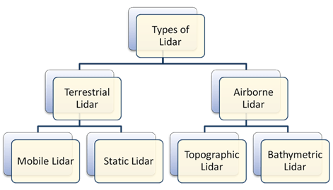
- Airborne LiDAR
Airborne LiDAR, as the name suggests, is the technology that’s installed on a drone or an aircraft for the collection of topographical data on the earth’s surface. The moment airborne LiDAR is mounted and ready to work, it focuses laser light towards the target object on the earth’s surface. This light is then reflected in the LiDAR source after it bounces off the target object on the ground. The geospatial information obtained is utilized in the determination of exact object distance.
There are two types of Airborne LiDAR: topography LiDAR and bathymetric LiDAR.
- Topographic LiDAR
A topographic LiDAR’s goal is to collect geospatial data of natural and human-made environments to determine earth’s surface models, such as contours, elevation models, et cetera. The information collected can be utilized by mapping professionals and even government agencies for urban planning, coastal engineering, emergency response operations, et cetera.
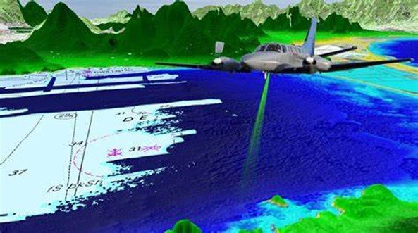
- Bathymetric LiDAR
Whereas topographic LiDAR and bathymetric LiDAR may have similarities in some aspects, bathymetric LiDAR’s unique feature is its ability to penetrate water. Nonetheless, information can be collected from both land and water by use of bathymetric LiDAR systems.
As soon as the bathymetric LiDAR system is activated, infrared laser light is cast upon the desired surface. The light from water and land surface is then reflected in the aircraft for data collection. Simultaneously, the other green light penetrates through the water to collect more data, for example, seafloor, land-ocean interface, et cetera.
Therefore, reliable planning information on ocean depth and land elevation can be obtained simultaneously through bathymetric LiDAR systems. This airborne LiDAR survey can capture accurate water-land interface, coastlines, banks, harbours, and shores. Additionally, objects on the ocean floor can be traced by the use of bathymetric LiDAR systems.
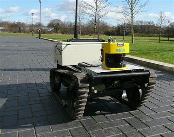
- Terrestrial LiDAR
Terrestrial LiDAR systems are either mounted on vehicles in motion or stationary objects like tripods at specific locations to collect 3D data of desired objects. These systems’ application is seen mostly on highways, railway stations, inside and outside buildings for collecting data points, or even analysis of infrastructure. The two categories of terrestrial LiDAR systems are mobile LiDAR and static LiDAR.
- Mobile LiDAR
Mobile LiDAR systems are terrestrial systems that are installed on vehicles in motion for the collection of data. To collect sufficient data of desired objects, several mobile LiDAR sensors are mounted on a moving platform. These sensors can be installed on trains, boats, vehicles, et cetera.
Like in airborne LiDAR systems, mobile LiDAR systems comprise the following components: inertial navigation system, cameras, sensors, and the Global Positioning System. The data obtained from mobile LiDAR systems can help analyze railway infrastructure, coastline layouts, road infrastructure, et cetera.
- Static LiDAR
Unlike mobile LiDAR systems, static LiDAR systems are mounted on stationary structures, like tripods, at a specific desired location to obtain lidar point clouds for 3D imaging. These tripods used for mounting these LiDAR sensors are fully portable for ease of positioning them in desired locations.
Furthermore, these systems can be installed in the interior and outside buildings for the same purpose of LiDAR cloud point collection. The applications of static LiDAR systems cut across the surveying, mining, and engineering industries, to mention a few.
How does LiDAR work?
The principle upon which LiDAR works is straightforward: cast a beam of infrared laser light on a target object on the earth’s surface and determine how long the same beam takes to return to the LiDAR sensor. The exact process of determining the distance of a target object on the earth’s surface is super-fast given the speed at which light travels through the air. The method of determination of the object distance is, however, very technical. It is half of the product of the speed of light and time of flight.
LiDAR applications
The evolution of LiDAR technology has made it popular across various industries and for a myriad of applications such as:
- LiDAR systems have been crucial in emergency response planning, mostly when maritime accidents occur. The exact ocean depth can be determined using bathymetric LiDAR systems for the location of desired objects beneath the water surface.
- The calculation and determination of ocean biomass is quite a challenging process. That is where LiDAR technology comes in.
- Moreover, LiDAR can be applied in the determination of land elevation and topography, information that’s crucial in road construction, building, and bridge construction. Its ability to utilize X, Y, and Z coordinates during 3D imaging leads to road and bridge construction authorities
‘ accurate decision-making.
- Finally, LiDAR technology has been effectively applied in the agricultural sector for the determination of yield rates and seed dispersion.
The bottom line
To conclude, LiDAR simply illuminates infrared laser light towards an object on the earth’s surface to calculate its distance. The time it takes for the reflected light to bounce back to the LiDAR source is used to calculate the object distance accurately.
The two broad types of LiDAR are airborne LiDAR and terrestrial LiDAR. Airborne LiDAR involves installing a sensor on an aircraft for the collection of geospatial data using 3D imaging. Airborne LiDAR is further classified into topographical and bathymetric LiDAR. On the other hand, terrestrial LiDAR involves the mounting of sensors on a moving vehicle or a static structure like a tripod or a building. Terrestrial LiDAR can be classified into mobile and static LiDAR.
LiDAR technology applications range from oceanography, land elevation determination to aid in road and bridge construction, and determination of yield rates in agriculture, to mention a few