
Last updated on November 24th, 2023 at 08:27 am
What is Resolution in Remote Sensing
Resolution in remote sensing refers to the amount of information that can be found in the image. Therefore, the higher the resolution, the higher the information that we can find in the image. It is basically the resolution referred to in cameras.
In remote sensing, there are Four Types of resolution in Remote Sensing.
- Spatial Resolution
- Spectral Resolution
- Radiometric Resolution
- Temporal Resolution
Spatial Resolution
What is Spatial Resolution
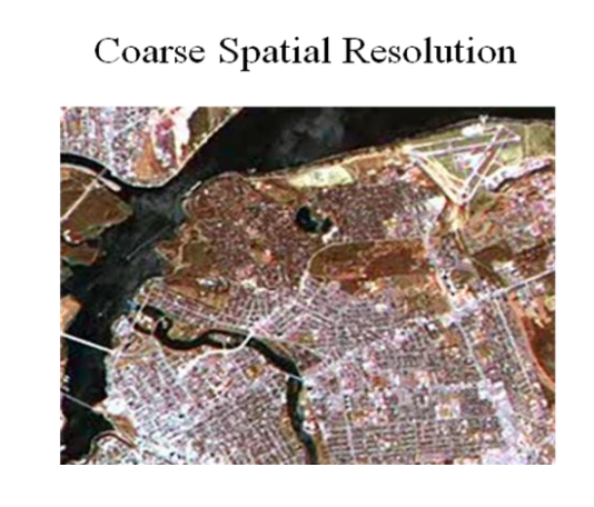
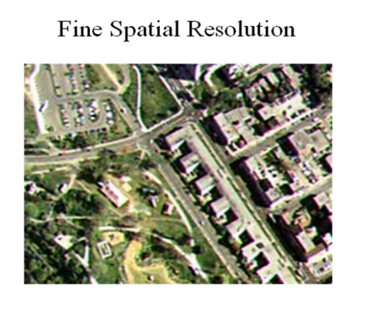
Spatial Resolution means that the amount of area covered by a single pixel in an image. That is a satellite having a spatial resolution of 100 meters will cover 100 meters of ground in a single pixel. This means that no data in the 100m area will be clearly visible. This is rather very unusable. For civilian satellites, no single person can be viewed clearly. The highest resolution sensor available, can cover up to just 30 centimeters in a pixel resulting in high res images. Even though it is not enough to PinPoint a single person with the satellite, it is sufficient enough to spot a car or a vehicle with a sensor of this resolution.
Factors Affecting Spatial Resolution in Remote Sensing
There are many things that might affect the spatial resolution in remote sensing, the important ones of those are as follows,
- Atmospheric conditions such as Clouds and Storms covering the area
- Ground Sampling Distance (GSD)
- Pixel Size and Image Size
- Field Of View ( FOV )
- Motion Blur and Geometric Distortions
- Data Processing Techniques (resampling, image enhancement)
- Object Distance and Scale
- Sensor Characteristics (type, design, platform)
- Limitations of Spatial Resolution such as high resolution demanding high storage and processing.
Spectral Resolution
What is Spectral Resolution
Spectral Resolution is nothing but the number of wavelengths of light a sensor can detect. For example a black and white camera can have 1 spectral resolution and a digital camera that can detect multiple wavelengths of color can be called multi spectral. There are sensors that can detect several hundreds and even thousands of bands and those are called HyperSpectral sensors. In Spectral resolution, the sensors can detect bands from visible light to ultraviolet or infrared frequencies. Thus overlay of images of several bands gives information such as temperature data from infrared and airglow or auroral or ozone measurement using UV data.
Factors Affecting Spectral resolution in Remote Sensing
- Sensor spectral range and bandwidth
- Number of spectral bands
- Spectral sampling interval
- Spectral resolution of the sensor
- Signal-to-noise ratio (SNR)
- Atmospheric conditions and absorption
- Spectral response of materials or targets
- Calibration and radiometric accuracy of the sensor
- Data compression and storage techniques
- Spectral characteristics of the sensor’s detector or imaging technology.

Credit: NASA JPL
Radiometric Resolution
What is Radiometric Resolution
Radiometric Resolution in remote sensing is the amount of information a sensor is capable of recognizing. The data is usually represented in the powers of 2. The image is usually black and white where the powers of 2 is the grayscale data. For Example, 2^4 means ( 1111 ) 4 bit binary representation meaning the maximum different data that can be represented. For 2^4 the maximum is 16 different values. Where as for 2^8 the values can be 256. Thus high quality images can be produced.
Factors Affecting Radiometric resolution in Remote Sensing
- Sensor bit depth or quantization level
- Dynamic range of the sensor
- Noise level in the sensor or data acquisition process
- Radiometric calibration and accuracy
- Atmospheric effects on radiometric measurements
- Sensor saturation or overexposure
- Data compression techniques and lossy compression
- Image processing algorithms and enhancements
- Sensor sensitivity and gain settings
- Sensor stability and drift over time.

Credit: Open Source
Temporal Resolution
What is Temporal Resolution
Temporal Resolution is the amount of time a satellite takes to observe the same area. Different Types of Remote Sensing Satellites have different temporal resolutions. Mostly Geostationary satellites sync the rotation with the earth’s rotation thus resulting in higher temporal resolution. Other Polar orbiting satellites has temporal resolution varying from 1 day to 20 days at most. These types of Polar Orbiting Satellites are useful for finding the daily changes to bi monthly or monthly changes in the Earth’s Surface.
Factors Affecting Temporal resolution in Remote Sensing
- Frequency of image acquisition
- Revisit time of the sensor or platform
- Availability and scheduling of the sensor or platform
- Data transmission and storage capabilities
- Sensor or platform lifespan and operational constraints
- Cloud cover and weather conditions affecting data acquisition
- Sensitivity to changes in illumination conditions (day/night)
- Image processing and analysis time
- Seasonal variations and cyclical phenomena
- Mission objectives and priorities for data collection.


