Ever wondered how pilots can easily navigate and survive the vagaries of weather in space? Or how meteorologists can predict weather patterns over some time? Either way, the simple comprehension of how the aircraft weather radar operates will give you a better understanding of how all these happen.
Even with the ground-breaking invention of the first aircraft in 1903, the first aircraft weather radar’s successful installation wasn’t until 1947. But still, a lot was desired in its subsequent development. Radar technology has been exploited so much that today’s aircraft weather radar can detect precipitation and storm intensities, enabling pilots to make informed decisions.
So, what is an aircraft weather radar?
An aircraft weather radar is a particular type of weather radar fitted to aeroplanes to figure out specific prevailing weather conditions for accurate decision making. It can be used to detect rainfall intensity, determine its movement, and measure other weather conditions such as snow, hail, etc. Most of the weather radars installed on planes today can detect water droplets’ movement and the intensity of rainfall.
Types of airplane weather radar
Almost every typical aeroplane utilizes three aids to help determine the weather, often called weather radar. They are divided into categories;
- Onboard radar for detecting and displaying weather conditions.
- Lightning radar.
- Weather radar receiving information from an external source.
Aircraft Weather Radar Operation :

As mentioned above, for effective detection of various weather conditions, an aircraft must be fitted with weather radar. Different aircraft sizes call for a customization of weather radars fitted into them.
- Onboard weather radar

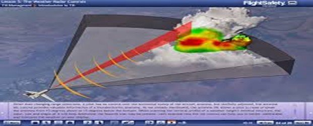
Airborne weather radar and the Air Traffic Control system operate more or less the same way. In the event an aircraft crashes, the radio waves emitted go back to the rain. They operate by sending radio waves into the atmosphere to detect precipitation intensity. In aircraft weather radar, these radio waves are meant to bounce off precipitation types, such as rain, hail, and snow. On the other hand, they are meant to bounce off of aircraft in Air Traffic Control.
Signals that are returned to the receiver are of varying intensities. Presence of heavy precipitation will send back signals that are stronger than when precipitation is light. The onboard weather radar receiver is set to display stronger returning signals as red, medium returning signals as yellow, and light returning signals as green on display on the plane’s deck
.
Clouds do not create the returning signals. Magenta displays the presence of dense or extreme atmospheric precipitation. The evolution of the airborne weather radar has led to the successful integration of its display into the overall aeroplane navigation display.
Weather radar often uses radio waves in the SHF range. The transmission of radio waves forward of an aeroplane is facilitated by a directional antenna located behind a non-metallic node. The returning signals are received by the antenna and processed accordingly. A precipitation type image is after that displayed on the screen.
To increase the aircraft’s air conditioning systems’ efficiency, it is built with the ability to distinguish turbulence, wind shear and hail, which are some of the pilot’s primary concerns. Since wind and other turbulences do not send back signals to the radar, such must be interpreted from precipitation movement patterns.
- Lightning radar

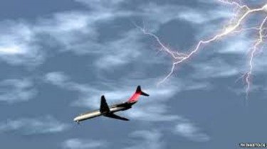
Lightning is one of the potential atmospheric threats that every pilot must be on the lookout for. Lightning emits its signals that can be detected on a lightning detector. A particular type of receiver (or antenna) fitted on an aircraft can be used to figure out a lightning strike’s strength. A lightning strike’s radial data from the aircraft can be useful in determining lightning intensity. A lightning strike that’s close to the aeroplane is considered intense, thus a threat. On the other hand, a lightning strike farther away from the plane is not quite a threat, and the pilot can easily navigate it.
A storm scope is a particular type of lightning detector that mainly aids in calculating lightning strike intensities. Most lightning detectors work similarly. There is a dedicated display fitted in an aircraft that’s able to plot lightning strikes. That is usually 200 miles away. The location of a lightning strike is usually depicted using a small mark on a display screen. As the marks change their colours, so is it easier to determine lightning intensity.
Nevertheless, a pilot can quickly and safely navigate a storm cell since the coverage of lightning strikes is around a small area. The plotting of the direction and intensity of lightning strikes can also be achieved on a multifunctional navigation display.
- Weather radar receiving information from an outside source
The evolution of weather radar systems has given rise to a third type of weather radar almost applicable in all aircraft classes. The uses of satellite systems orbiting space in the aviation industry cannot be overemphasized. Through these systems, aircraft can receive general weather information to enable pilots to make informed navigation decisions.
Weather information can be sent virtually to any aircraft anywhere in the world. This data is transmitted can either be real-time weather or in the form of a text. This real-time weather information can be viewed on an aeroplane’s navigation displays.
But still, before the pilot can utilize this transmitted weather data, it’s first refined by the use of the aircraft’s weather radar systems and satellite imagery. This refinement produces more accurate and reliable weather condition data. Moreover, the availability of supplemental data of prevailing weather conditions from the National Weather Service (NWS) and other meteorological intelligence can be used to reinforce the accuracy of navigation decisions made by pilots.
Modern aircraft are fitted with antennas and associated transceivers to enable them to receive satellite weather services.
The bottom line
In conclusion, an aircraft weather radar is simply a type of radar used to send radio waves to determine the location and type of precipitation, and calculate its intensity. The three types of weather aids in modern aircraft are the onboard radar to detect and display weather conditions, the lightning radar, and the weather radar for receiving outside intelligence.
An aircraft weather radar works the same way the Air Traffic Control system does, except the signals it sends bounces off precipitation instead of an aircraft. The intensity of precipitation can be depicted using either red, yellow, or green colours on the display screen.
A lightning strike’s radial data from a lightning detector can be utilized to determine the strength of lightning. Moreover, weather data sent to an aircraft is refined using orbiting satellite systems to provide pilots with intelligence on prevailing weather conditions.


