
Last updated on August 13th, 2023 at 04:00 pm
What Is LIDAR ?
LIDAR stands for Light Detection and Ranging. It is used in generating 2d and 3d maps of the environment primarily by using two measurement techniques, TOF ( Time Of Flight } and Laser Triangulation. Though lidar can be used for many applications, its primary use case is in autonomous vehicles for generating a 2d or 3d map of their environment and using the generated map to Localise ( Finding where the vehicle is by comparing with the generated map ) and navigate to the destined location.
How does LiDAR work?
A Light source such as Laser is mounted on top of a rotating plate and the light source sends out a beam of light at a particular frequency and waits for the light to reflect off of a surface. By calculating the time taken for the light to be received, the distance between the source and the object is determined. Since the Light source is placed on top of a rotating platform, the platform can be rotated to every angle and the object at 360° is captured and a 2D map is generated. When multiple light sources are stacked on top of each other and the same process is repeated, we get a 3D mapping of the environment.
So, does all lidar have a 360° FOV ( field of view )? Nope, some lidars have 180° and some have 270° FOV. The lidar to choose is up to someone’s requirements.
Likewise, all lidars don’t just collect one data per degree. The rotating plate of the LiDAR is rotated with the help of a Stepper motor in most cases. Thus, the step angle of the motor decides the resolution of the LiDAR. Some common angular resolutions of lidars are 0.09°, 0.18° and 0.36°. Some Lidar come with variable Angular resolutions based on the Rotation frequency that one can programmatically choose.
With all these, a 2D lidar just has a Horizontal FOV, where as a 3D lidar has both Vertical and Horizontal FOV. The Vertical FOV is usually mentioned in the lidar as the number of Channels in it.

How to connect a LiDAR and read data from it?
Most modern Lidars connect with your computer with a USB port. Both power and data can be taken from the USB itself. But these types of lidars don’t have high data frequency and does not provide high resolution because of the limited power and data restraints of USB ports.
But high level lidars take separate power sources and let you connect with them via a network port. Thus enabling one to connect to multiple lidars if needed and also providing reliable and high data transfer speed allowing one to operate the Lidar in high resolution modes.
The mode changing and other configuration to lidar in most lidars are done using MODBUS communication.
As for reading data from lidar and interpreting it, since the lidar is mounted on top of a rotating platform, the data we receive from a lidar is in the polar coordinates. Unlike our familiar Cartersian coordinate system that uses the X and Y axis, the polar coordinate uses θ ( theta ) – Angle and the r – Radius.
To convert the data from the polar coordinate to cartesian coordinate, the following formula is used and the data is used to plot on the map or in the rviz tool.
x = r cosθ
y = r sinθ
For every point in the data which is the 360 divided by The Angular resolution of the sensor, the data needs to be converted and plotted on a map.
Uses of LiDAR in different fields.
Robotics
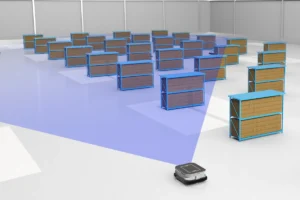
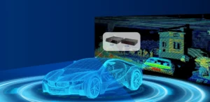
The main place where lidar is used is in the Autonomous vehicles and Autonomous robots. The use of lidar here is for localisation and navigation purposes.
Aerial Inspection
The lidar is mounted on top of a Drone or a UAV and it is used for industrial inspections, powerline inspections, industrial asset monitoring and so.

Agriculture
Lidar along with other sensors is used in Agriculture for identifying location to irrigate instead of irrigating the entire area thus saving water and other resources.

Lidar in Space
Lidar is used in robots that are mapping the other planets and natural satellites like the moon. But one other peculiar use case that I first hand saw for the use of lidar in space is for docking in space.

Credits: NASA
Conclusion
Lidar is a fascinating sensor technology that has gained popularity in recent times because of its precision and reliable use case in 2D and 3D mapping of the environment. Lidar finds extensive application in autonomous vehicles, where it assists in mapping the surroundings, localizing the vehicle, and facilitating navigation. It is also employed in fields such as surveying, environmental monitoring, archaeology, forestry, and urban planning, providing detailed spatial information for various industries. Moreover, lidar plays a role in space exploration, aiding in docking and rendezvous operations between spacecraft. With its ability to generate high-resolution maps and precise measurements, lidar continues to be a valuable technology for understanding and interacting with the physical world.


Pingback: LIDAR Versus Infrared - LIDAR and RADAR
Pingback: Different Types Of Remote Sensing - LIDAR and RADAR
Pingback: 2D LIDAR Versus 3D LIDAR - LIDAR and RADAR
Pingback: LiDAR Vs LaDAR - LIDAR and RADAR