Last updated on August 9th, 2023 at 12:34 pm
What is DGPS?
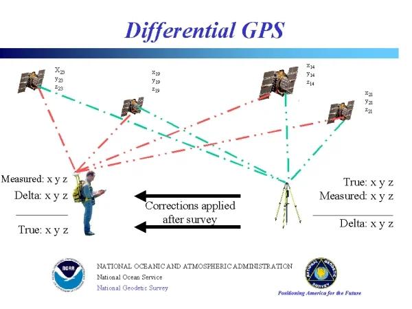
DGPS or Differential GPS is a technique used to improve and enhance the accuracy of the Global Positioning System ( GPS ). The nominal accuracy of a GPS system is around ± 15 meters and the DGPS technique can increase the accuracy of the data to ± 3 cm ( centimeters ). This is achieved by adding multiple highly accurate ground reference points and calculating the error in the less accurate satellite data and the error is broadcasted to the local receivers thus forcing the receiver system to correct the error from Satellite data to achieve high accuracy.
What is DGPS used for?
DGPS is used for multiple applications and mainly used on applications where high accurate GPS data is needed. Below are some of the main applications of the DGPS.
Land surveying and mapping:
DGPS helps land surveyors to create highly accurate maps with detailed distance, angles and
elevations.
Marine navigation:
In marine, the high accurate data from DGPS is used to safely and efficiently passage through highly challenging waterways and avoid hazardous while maintaining the course.
Aviation:
DGPS ensure safe takeoff, landing and in-flight navigation in the aviation industry. Since its high accuracy, DGPS helps pilots in following the designated flight paths and avoid collision in mid air.
Agriculture:
DGPS is mainly used in precision agriculture where the fields are mapped and guided machinery are used in optimizing the crop management. Thus helping farmers optimize resources, minimize waste and enhance yield.
Difference between DGPS and GPS:
| Feature | DGPS | GPS |
|---|---|---|
| Principle | Utilizes reference station data and correction techniques to enhance accuracy | Relies solely on satellite signals for positioning |
| Accuracy | Offers improved accuracy, often down to sub-meter or centimeter levels | Provides satisfactory accuracy for everyday applications |
| Error Reduction | Minimizes errors caused by atmospheric interference, satellite clock errors, and signal degradation | May be affected by atmospheric conditions and signal interference |
| Application | Used in industries requiring high accuracy, such as land surveying, marine navigation, aviation, and precision agriculture | Suitable for general positioning needs |
| Reference Station | Uses reference stations located at known positions to collect data for corrections | Does not require reference stations |
| Real-Time Correction | Can provide real-time correction data for instantaneous accuracy improvement | Does not offer real-time correction capabilities |
| Equipment | May require specialized DGPS receivers or compatible devices | Standard GPS receivers are commonly used |
| Cost | May involve additional costs for access to reference station data and specialized equipment | Generally more cost-effective |
What is DGPS types?
DGPS is a technique that’s used on top of GPS to improve the accuracy of the GPS data by using error correction techniques to offset the value. There are two primary types of DGPS,
- Real-time DGPS (RT-DGPS)
- Post-processing DGPS
Real-time DGPS (RT-DGPS):
In Real Time DGPS, the error correction data is transmitted from the base station through radio to the receivers. This enables spontaneous correction data to be broadcasted to the receivers and thus it is suitable for time sensitive applications and in places where real time positioning data is needed.
Post-processing DGPS:
Post processing DGPS can give better accuracy by collecting data from multiple GPS systems and reference stations. The post processing method needs the data to be stored on a file and processed against the GPS data with a special software. This method also needs the data to be time stamped and stored and processed. Thus the method demands more time for processing but provides higher accuracy.
Is DGPS better than GPS?
Yes, It is better than GPS. Mainly it is better because the accuracy of the DGPS is way better than GPS which is thousandfold less accurate. The list of advantages that DGPS offers over GPS are High accuracy and precision, Reduced error and Enhanced reliability.
However, DGPS highly relies on the reference station data. Thus the reference station connection is needed and this the case for both real time and post processing of DGPS which might incur certain costs. But for less accurate requirements, normal GPS is suitable.
Common DGPS techniques
The DGPS uses multiple techniques to achieve high accuracy and precision. Some the most common methods are,
Code-based DGPS:
Code based DGPS uses error correction to the measurements received from the GPS satellites
Based on the reference data received from the reference station. This method is simple and improves the data accuracy significantly. This is more commonly used on the standard GPS receivers.
Carrier-phase DGPS:
Carrier-phase differential GPS (CDGPS) increases accuracy of the GPS data by correcting the carrier-phase measurements obtained from GPS signals. It achieves centimeter level accuracy by accounting the phase data and applying corrections received from the reference stations. The only cons is that this requires specialized equipment and processing algorithm which might increase cost.
Satellite-based augmentation systems (SBAS):
SBAS is a type of DGPS that uses additional satellite signals to increase the GPS constellations. Systems like Wide Area Augmentation System (WAAS) by the United States Government and the European Geostationary Navigation Overlay Service (EGNOS) in Europe provides wide-area correction information, thus improving GPS accuracy across large regions.


Pingback: Lidar Vs Remote Sensing - LIDAR and RADAR
Pingback: How GPS Satellites Work - LIDAR and RADAR
Pingback: 19 Applications of GPS ( Global Positioning System ) - LIDAR and RADAR
Pingback: GPS vs GLONASS vs Galileo - LIDAR and RADAR
Pingback: Global Satellite Navigation System - LIDAR and RADAR
Pingback: 11 Frequently Asked Questions on GPS - LIDAR and RADAR
Pingback: GNSS Bands - LIDAR and RADAR